|
|
GeoAstro Applets |
Astronomy |
Chaos Game |
Java |
Miscel- laneous |
Sun and Moon Lozenge Applet
|
Using the scroll bar arrows to set the latitude. Select from the menu to show or hide details:  Bush
Barrow - near Stonehenge, 51.17° N - is a site
of the early British Bronze Age (ca. 2000 BC),
excavated in 1808 by Sir Richard Colt Hoare and
William Cunnington. The barrow contained a male
skeleton with rich funerary goods, including a
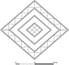
large 'lozenge'-shaped sheet of gold, about 0.5
mm thick.
The
parallelogram (lozenge) is measuring 18 cm
across. It might have served as a solar and
lunar calendar, using the sight lines pointing
in the direction of Sun solstices and lunar
standstills.
 Azimuth angles of the Sun (red): rise and set at summer solstice rise and set at winter solstice rise and set on May 1 (Beltane), declination about +15° rise and set on November 1 (Samain), declination about -15° Azimuth angles of the Moon (blue): northern and southern rise and set at major lunar standstill northern and southern rise and set at minor lunar standstill The azimuth angle az of rise and set depends on the declination δ and the latitude φ. Neglecting atmospheric refraction the angle for a mathematical horizon can be computed by the formula: cos az = sin δ/ cos φ
At 51.17° N the sizes of the arcs for rise and set are (2000 BC): solstices: 80.6° solar arc May 1 to November 1: 49.1° major lunar standstills: 101.6° minor lunar standstills: 61.8° At 51.17° N the ratio of the lozenge axes NS/EW is 0.821.
|
Lunar standstills
|
|
|
Bush Barrow Gold Objects (Wiltshire Heritage Museum) D.P. Gregg: The Stonehenge Code (PDF) Clive Ruggles: Ancient Astronomy - An
Encyclopedia of Cosmologies and Myth (PDF), p. 52 |
| Books, Articles |
| Archibald Thom: The
Bush barrow gold lozenge: is it a solar and lunar
calendar for Stonehenge? in: Studien zur Megalithik - The Megalithic Phenomenon, edited by Karl. W. Beinhauer, Beier & Beran, Weissbach 1999. p. 289 - 307. |
Last modified: 2023, Oct 07
